Architect
Mario Schjetnan, Mexico City; Ptillo
Garret/PGA, Oakland California
Type of Area
Bay
Land/water interaction
Riprap
Pier
Promenade
Built Environment Types
Completely built
Scale of Impact
District/neighbourhood
Intervention Scale (Spatial)
Moderate site
Project Types
Urban waterfront restoration
Public green space regeneration
Outdoor recreation
Urban/ Rural
Inner urban area
Visibility and Openness
Fully enclosed
Fully contained view
Industrial Space Transformed
The Union Point Park forms part of a system of parks and trails in the San Francisco Bay area. This 3.6-acre waterfront site is a mix of commercial and residential development that provides an attractive open space in an area of Oakland previously lacking such space. The park, developed on a previous industrial site, is inspired by coastal landscapes with dunes in a series of mounds. A 7m high mound provides excellent views across the bay.
Union Point Park largely serves the local immigrant community and reflects the vision and collective efforts of a broad range of community groups, agencies, and individuals. Use of marine artefacts, such as ship cleats, offers a sense of place and adds to the layers of history, meaning and myths. However, as the site views from the access road are missing landmarks or focal points, it therefore lacks character and identity. The primary recreational uses include boating activities connected to the marina, walking and cycling along the extensive pathways, viewing and fishing. The site provides sufficient parking, a children’s play area and spaces for picnicking socialising, family gatherings and performance events.
Recreational opportunities are enhanced by a mix of hard and soft surfaces, pergolas for shade, piers, benches, trees and pathways. Facilities include sheltered picnic areas with barbeques and public toilets. Riprap on the shore edges, bridges and piers offer informal seating spaces to enjoy the view close to or over the water. The children’s play area equipment, inspired by the shape of a ship is interesting and unique. The design of the park, however, did not consider the chilly onshore wind. Wind breaks are provided which force people to use those spaces for picnic spaces, which are limited as the place gets overcrowded. Despite having good facilities, the site feels unsafe due to the large number of homeless, litter and substandard toilet facilities.
Perception and Meaning
Imageability
Legibility
Accessibility
Place identity
Place attachment
Health and Wellbeing
Place affordance
Restorativeness
Increased physical activities
Increases socialisation
Aesthetic experience
Interaction with Water
Visual
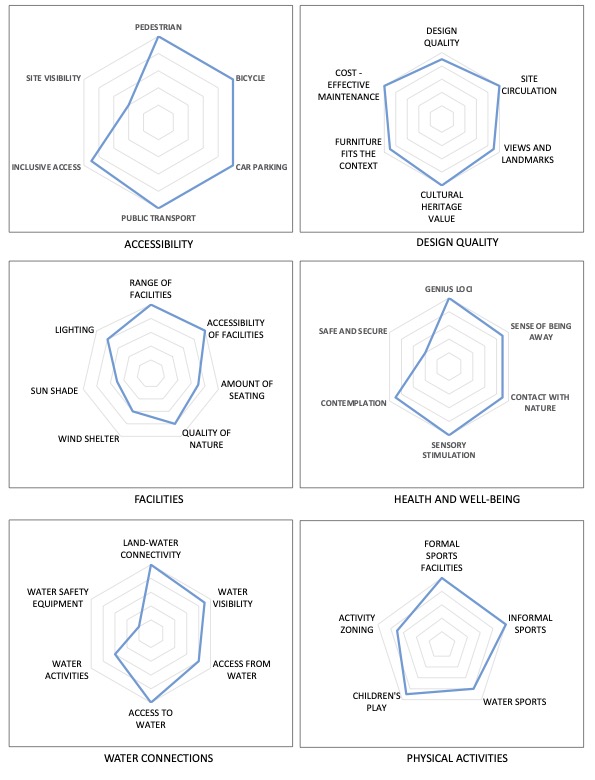
The site is situated besides the Embarcadero road a dual carriage way city street and has vehicular entry points at northern and southern end of the site into large parking lots. The pedestrian connection to the site from the surrounding area is weak, however. Clean paths made from concrete slabs, makes it convenient for people with disabilities; however, the coastal path is not continuous and stops at the edge of the site. The site is can be accessed by boat due to the presence of the marina. There is no public transport provision near the site within 400 m walking distance.
The overall design quality is excellent and makes good use of the artifacts from its industrial heritage. The dunes also improve the access to views across the bay area. The range of facilities is good but lacks enough protection from the sun and chilly onshore winds.
There is scope for many formal and informal physical activities in the open spaces. Health and well-being potential overall is excellent as a site that provides green space designed in collaboration with the local community. Footpaths and piers also have protective railings. However, more recently the site feels less secure due to the presence of homeless and other people. Water safety is also a potential issue along the shoreline.