Architect
RietveldLandscape
Atelier de Lyon
Type of Area
Artificial lake
Land/water interaction
Pier
Embankment
Built Environment Types
Low built
High green
Scale of Impact
Regional
Intervention Scale (Spatial)
Small site
Project Types
Cultural regeneration
Urban/ Rural
Urban fringe
Visibility and Openness
Partly enclosed
Partly contained
A path through history
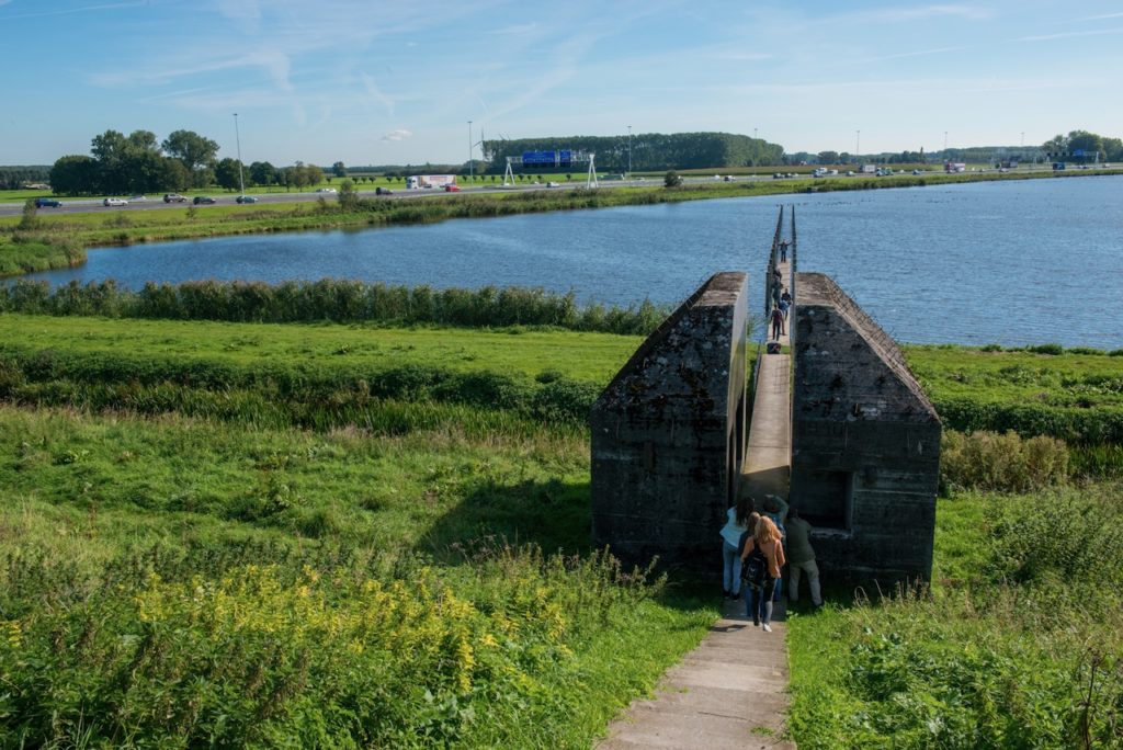
Bunker 599 forms part of the military landscape of The New Dutch Waterline- a protective ring around the cities of Holland that was operational during the First and Second World Wars. During the war, this 85 Km long and 8 km wide area was flooded under half a metre of water to prevent enemy attack from the east.
There are more than 700 surviving concrete constructions, visible from many locations in this contemporary landscape and Bunker 599 is an example of how military heritage can find a new purpose and function. This object was built of reinforced concrete in 1940, measuring just 7.2m X 5.7m X 4.65m, with a 2.15m thick roof and 1.8m thick wall. It provided space for 13 men to shelter from bombing raids.
The new design took a slice through the apparently indestructible-looking structure to expose the small, dark interior, which is normally hidden from view, and inserted a pathway through its centre which leads to a concrete jetty that projects deep into the water. Vertical posts, 1.8 m tall, support the jetty and give a reference to past water levels. The project opens up the bunker and water to tourists, who can experience the military heritage, as well as take advantage of being close to the water. Many people can also view the object as they pass along the highway.
Perception and Meaning
Knowledgeability
Sense of place
Health and Wellbeing
Tranquility
Aesthetic experience
Interaction with Water
Visual
Website of the project:
Google map reference
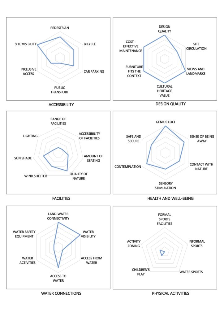
Accessibility to the site has been improved by the addition of a set of steps, which links the bunker to footpaths in the adjacent nature reserve; however, the steps restrict disabled access to the site, so inclusive access is low, as is accessibility by bicycle. The terrain does not allow ramps to be inserted so I tis only possible to use steps.
The cultural heritage associations are strong for this site, as it improves access to a historical monument and highlights the water depth at this site when the moats were flooded during the Second World War. These features give the site legibility and a connection to the past, in keeping with its position in the landscape.
The scale of the site restricts the facilities available but its natural setting enhances the accessibility of the public to nature and strengthens its sense of place. The thick walls of the bunker, its sense of history with connections to ordinary soldiers who were stationed there together with the jetty out onto the water aid the site’s role as a space of contemplation and a sense of being away.
The footpath that stretches from the network of pathways, through the bunker to the jetty with a clear uncluttered view presents a strong connection and bridge from the land to the water, as well as a clear visibility of the water. Water activities, however, are not a feature of this site, understandably so given its primary role as a historical monument and close to a nature reserve.