Architect
Broadway Malyan Manchester
FoRM Associates
Type of Area
Medium-sized river with artificial banks
Land/water interaction
Harbour
Promenade
Terraces/steps
Built Environment Types
Completely built
Scale of Impact
District/neighbourhood
City
Regional
Intervention Scale (Spatial)
Small site
Project Types
Riverfront development
Economic regeneration
Urban/ Rural
Urban core
Visibility and Openness
Fully enclosed
Fully contained view
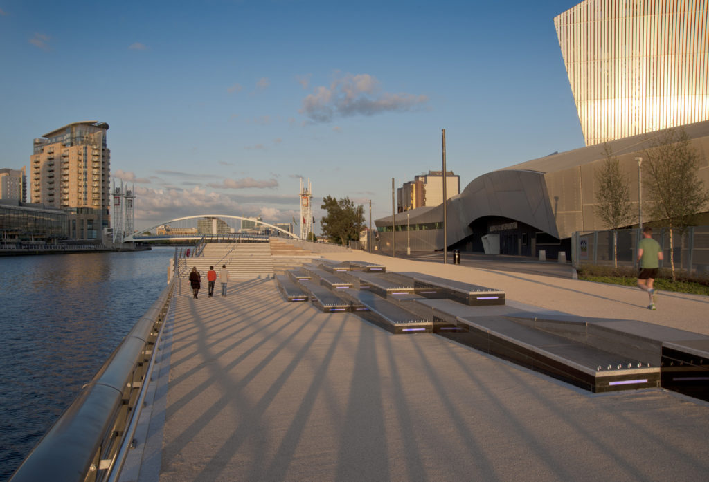
A Popular Lunchtime Spot
Manchester, Salford and Trafford were thriving urban industrial areas built on the textile industry. The River Irwell and its canal were at the forefront of the development with both recreational and commercial functions. Heavy pollution, however, destroyed the river’s ecosystems and the docklands suffered with the decline of the mills. The cities turned their backs on the neglected and degraded river.
At the end of the 20th century efforts were made to restore the original ecosystems and reclaim the waterfront, by the Central Salford Urban Regeneration Company, formed to coordinate between local government and private businesses. The river corridor was to become a symbolic connection between the fragmented communities. It aimed to bring a cooling environment to mitigate urban heat island effects, provide sustainable drainage in this rainy climate, as well as recreational facilities. This was also seen as an important aspect of the Green Infrastructure development.
Initial developments did not capitalise on the River Irwell assets and it remained an invisible boundary. The new buildings did not connect with the riverside location, like the Imperial War Museum with its entrance located on the opposite side. Previously the river came right up to the Imperial War Museum building, so piles were sunk into the river to construct an extension to the promenade around it, creating a symbiosis between the robust museum building and the softer edges of the river. The entrance of the museum was moved to the riverside increasing visitor numbers, thus the public space created added value. In addition, the BBC centre located across the river, began to use the newly created riverfront as a backdrop for outside news broadcasts.
The project brief required minimal maintenance with robust materials. The place had to be vandal proof due to its proximity to a football stadium. Convex and concave geometrical forms were incorporated into the design, echoing the lapping water and wide terraces allow pedestrians and cyclists to get close to the water. The terraced construction is connected via steps and ramps to facilitate accessibility and to provide seating with views across the river, thus, it is a popular lunchtime spot. Blue lights increase its potential for night-time use.
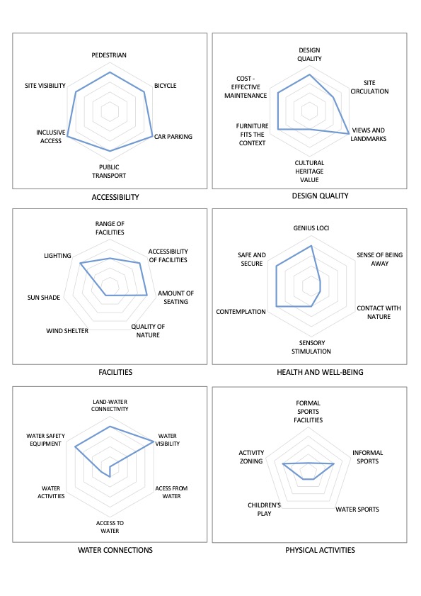
Perception and Meaning
Imageability
Legibility
Place identity
Accessibility
Focal point
Health and Wellbeing
Place affordance
Restorativeness
Aesthetic experience
Interaction with Water
Visual
Website of the project:
http://markoandplacemakers.com/projects/trafford-wharf-promenade-manchester-uk
http://markoandplacemakers.com/sites/default/files/01%202012%20ARCH%20Igor%20Marko.pdf [Slovak]
https://www.archdaily.com/180822/trafford-wharf-promenade-form-associates
Google map reference
The construction is ideal for seating, relaxing, walking, cycling, socialising, lunch time visits, sunbathing and meeting friends and relatives. The brief was for no or little maintenance and so greenery is limited to a small birch grove to provide shade or to soften the environment; contact with nature, therefore is low.
There was also a condition in the brief that the museum had to be visible from the other side of the river from the BBC .i.e. there were to be no optical barriers. The visibility of the installation, therefore, is low key to emphasise the dramatic form of the Imperial War Museum.
Access to the river is limited, but in a busy city centre with a proximity to a football stadium nearby, this is perhaps understandable and the railings therefore provide a safer environment without obscuring the view of the river too much. Also, the focus is on recreation by the river rather than on the river, so formal sporting activities are not provided.