Architect
Teresa Möller & Associados
Type of Area
Ocean
Land/water interaction
Stony beach
Built Environment Types
Low built
Low green
Scale of Impact
Block
Regional
Intervention Scale (Spatial)
Linear development
Project Types
Seafront development
Outdoor recreation
Urban/ Rural
Sub-urban area
Visibility and Openness
Fully open
Fully horizon
Rugged Simplicity
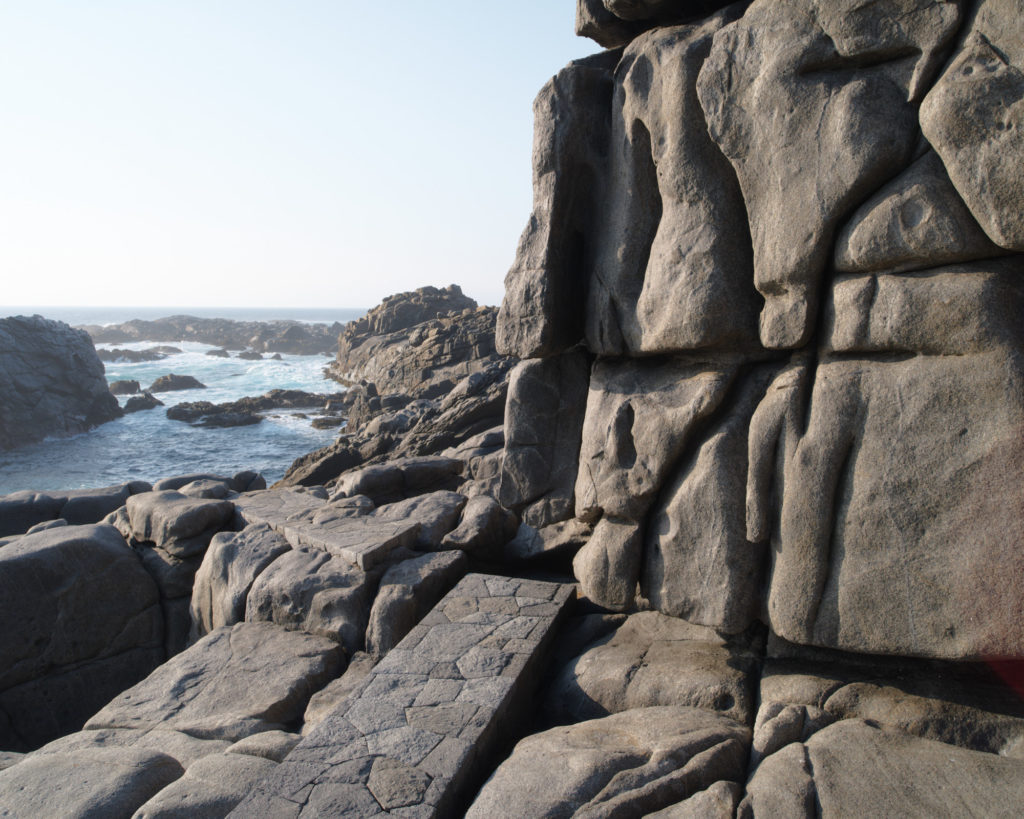
Rambla Punta Pite is situated on the Pacific coastline of Chile, 150km north of Santiago. It is a rugged natural headland pummelled by the ocean waves. The fissured rocks create a difficult terrain for walking and so this project aimed to improve the accessibility of this steeply sided coastline without compromising the raw character of the place. Pathways and steps were only situated in areas where walking was difficult with other areas left untouched. Exploration is encouraged and opportunity provided to take in the panoramic scenery. Compared to most BlueProfiles this is not an urban site but we considered it to be a special case and worthy of inclusion.
The pathways are created from rocks found on-site, that had been removed from the beach by a previous owner, and therefore they blend perfectly into the landscape. The stonework forms a link to the past, constructed without a visible layer of concrete, reminiscent of traditional craftsmanship. Sculptors and stonemasons (Gerardo Ariztía and Francisco Araya) collaborated together to hand cut the granite stonework over a period of two years, learning along the way. Their work leaves a lasting legacy of solid pathways that cling to the cliffs but also stone masonry skills for future generations that is now being employed across Chile.
The project evolved according to the rules laid down by the designer, Teresa Mollor. Only straight lines were used, empty spaces were left when changing direction and leaving the rock untouched where it was possible to walk. Irregular areas were levelled and trapezoidal shapes formed that define the spaces along the rocky headland. The designs were only completed after the project was finished; weekly site visits were used to design the project in an iterative way. Plans were made with bamboo sticks and string to define the next stage and water used to define the level.
Perception and Meaning
Genius Loci
Legibility
Sense of place
Accessibility
Health and Wellbeing
Tranquility
Restorativeness
Attention
Aesthetic experience
Sense of being away
Interaction with Water
Visual
Tactile – touching
Website of the project:
http://teresamoller.cl/portfolio/punta-pite/
Video of the installation
https://www.architectureplayer.com/clips/punta-pite
Google map reference
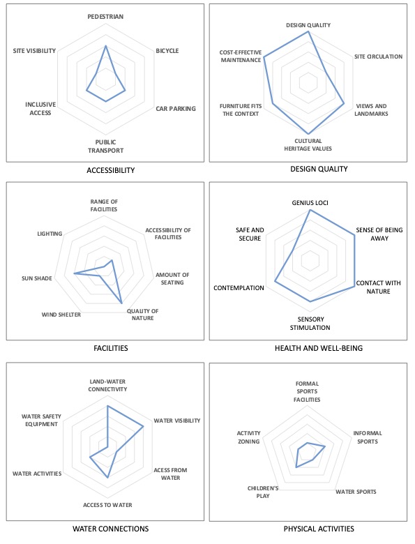
The scores for this project are understandably low for accessibility and the range of facilities due to the challenging topography. It is an exposed, windswept site – features that are part of its character. It provides better access to a dramatic landscape but does this in a way that is sympathetic with it. It is not very visible, as the intention is to blend into the background using the materials from the rocky site. The health and well-being and genius loci aspects score highly as the project enables a really close and dramatic experience of the landscape to be obtained – a sublime aesthetic, strong sense of being away and close to nature.
It scores high on cultural heritage values due to its connection to the past stonemasonry feats of the area and the fact the project has created a legacy of craftsmanship for the future. The construction is very robust and virtually maintenance free. Land water connectivity is high as it brings people close to the water in an otherwise relatively inaccessible place. Steps allow people to get much closer to the water. However, the rocky promontory with the pounding surf does not allow for safe water sport activities and therefore, again is understandably rated low.