Design concept
Initial idea: Bertrand Delanoë, Mayor of Paris.
Type of Area
Large river with artificial banks
Land/water interaction
Embankment
Promenade
Built Environment Types
Completely built
Scale of Impact
District/ neighbourhood
City
Intervention Scale (Spatial)
Linear development – Multiple interventions
Project Types
Riverfront development
Urban/ Rural
Inner urban area
Visibility and Openness
Fully enclosed
Fully contained view
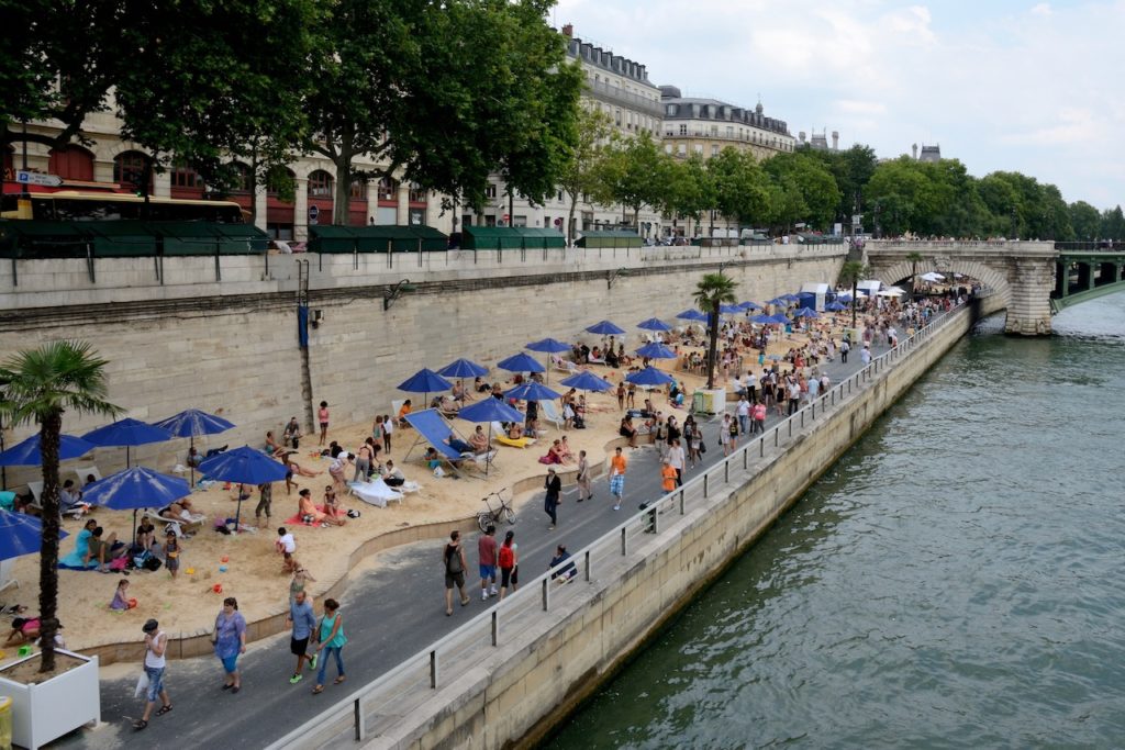
A Beach in the City
Paris Plages is a pop-up summer intervention carried out by the municipality of Paris since 2002 on the banks of the Seine as a public-private partnership in different stages. Each year, between mid-July and the beginning of September, the path on the right bank of the Seine and connected areas host different leisure and sporting activities with sandy beaches, mobile palm trees and resting possibilities on a length of what is now more than three kilometres of riverbank, with more than one kilometre of fine sandy beach and additional connections to other parts of the city centre, thus changing the morphology of the river banks. Vehicle traffic is interrupted at this segment of the expressway running parallel to the river for the duration of the whole event, from its installation until its final dismantling, to make the riverbank accessible to pedestrians and cyclists. As a capital and a major economic centre Paris always had huge parts of its inner city circulation routes connected along the Seine since the decline of harbour activities and the river and city became disconnected. In recent years’ discussions about a long-term traffic reduction in Paris have started.
Before the Paris Plages event was initiated, a closure of the expressway to traffic took place every Sunday from 1995. Based on these experiences, the municipality decided to extend this operation to the whole summer because during this period of lower economic activity the centre of Paris usually experiences less traffic. The main objective was for Paris inhabitants to enjoy an inner city vacation with all of the activities which are normally practiced on coastal beaches. Since Paris Plages appears during the official summer holidays, the scenography of the event is staged each year by different artists on the theme of, for example, French Polynesia or Brazil for the activities and spaces. In this sense, Paris Plages can be understood as part of the Tactical Urbanism movement by employing temporary events to raise awareness towards urban problems connected to traffic, pollution or social congestion in cities which would finally materialise into long-lasting infrastructure and elements.
In 2006, together with the opening of the left bank of the Seine, floating basins have also been installed on the river, as well as introducing a shuttle to connect the different sections of Paris Plages. As an extension of activities further from the river, a new site at the basin de la Villette was opened in 2007, including nautical activities, children’s play, outdoor gyms and large picnic areas. Opening the pools was considered to be one of the measures to mitigate heat waves, which Paris has experienced several times over the last decades (Ouzeau at al., 2016; Chrisafis 2019). Furthermore, the entrances were transformed and highlighted to create better visibility of the access to the beaches from the road, as part of a new relationship between city and river. Thus we can see here how a small and temporary project has actually grown and developed – it is still tactical urbanism but it has outgrown its original small scale.
Perception and Meaning
Sense of ownership
Legibility
Health and Wellbeing
Restorativeness
Place affordance
Increases socialisation
Interaction with Water
Visual
Website of the project:
https://en.parisinfo.com/discovering-paris/major-events/paris-plages
Google map reference
Waiting for details.