Architect
H+N+S Landscape Architects, Trafique
Type of Area
Large river with natural banks
Large river with artificial banks
Land/water interaction
Riprap
Bridges
Sandy beach
Built Environment Types
Low built
High green
Scale of Impact
City
Regional
Intervention Scale (Spatial)
Large site
Project Types
Flood protection
Riverfront development
Outdoor Recreation
Urban/ Rural
Inner urban area
Visibility and Openness
Fully enclosed
Fully contained view
Ecology, People, Flood protection.
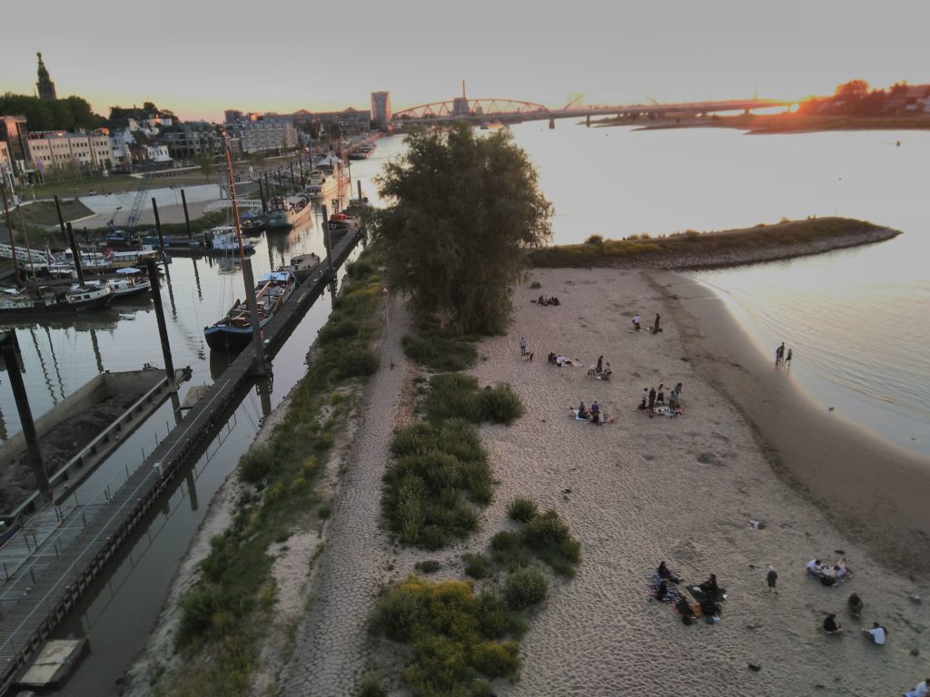
The Room for the River Waal project is situated on a sharp bend of the river Waal, near the city of Nijmegen. It formed a bottleneck leading to several serious flooding events. It is part of a wider project aimed at safely managing floodwaters to protect Dutch inhabitants. The ecologically sensitive design takes into account the river’s tidal nature and the erosion and sedimentation processes.
The plan incorporates three layers: creating, growing and water movement. The ‘creating’ layer involves the project’s constructed elements; the ‘growing’ layer is the development of the natural and built landscapes and allows space for characteristic ecotypes to develop in the river landscape; the temporal third layer, ‘water movement’, comprises the seasonal changes as water levels fluctuate.
The community has been involved in introducing measures at over 30 locations to give the river room for mitigating the flood risk and improve the quality of the immediate surroundings. The Waal dike in Lent was removed and a secondary bypass channel was constructed in the flood plains creating an elongated island between the historic city centre and the north shore of the river. Dykes have been relocated inland to widen the floodplain and other dykes modified to allow for flooding, creating temporary storage areas. Other modifications have been made to improve the water flow such as reducing groyne heights, deepening the riverbed, removing accumulated sediment to lower floodplains and removing obstacles that hampered the flow of the river.
The island, which integrates archaeological and historical elements of the area, forms an urban river park providing opportunities for recreation, cultural events and access to water and nature. Pathways have been constructed for walking, although at high-water some paths will flood and are only accessible via stepping stones. The area also provides seating with views across the river and opportunities for fishing and sunbathing.
Perception and Meaning
Legibility
Accessibility
Knowledgeability
Health and Wellbeing
Restorativeness
Aesthetic experience
Increased physical activities
Interaction with Water
Visual
Tactile – Partly in water
Accessibility for this site overall is excellent, as it has improved connectivity to the water by adding several new bridges to the area and a series of pathways that leads people to the beach area. Due to the nature of the site, however, it scores slightly lower in inclusive access as wheelchair access is hampered.
Overall the site provides many recreational options as well as protecting the city from flooding events, thereby improving the health and wellbeing of the city inhabitants in an ecologically friendly manner. Although shade from the sun and wind is low, this site is an evolving one and over time the trees and bushes may provide more shelter, depending upon how the evolution of the site takes place.