Architect
OLIN
Type of Area
Streams with natural banks
Land/water interaction
Promenade
Flood plains
Riprap
Built Environment Types
Highly built
Low green
Scale of Impact
Block
District/ neighbourhood
City
Intervention Scale (Spatial)
Large site
Project Types
Green infrastructure
Public space regeneration
Outdoor Recreation
Urban/ Rural
Inner urban area
Visibility and Openness
Fully enclosed
Fully contained view
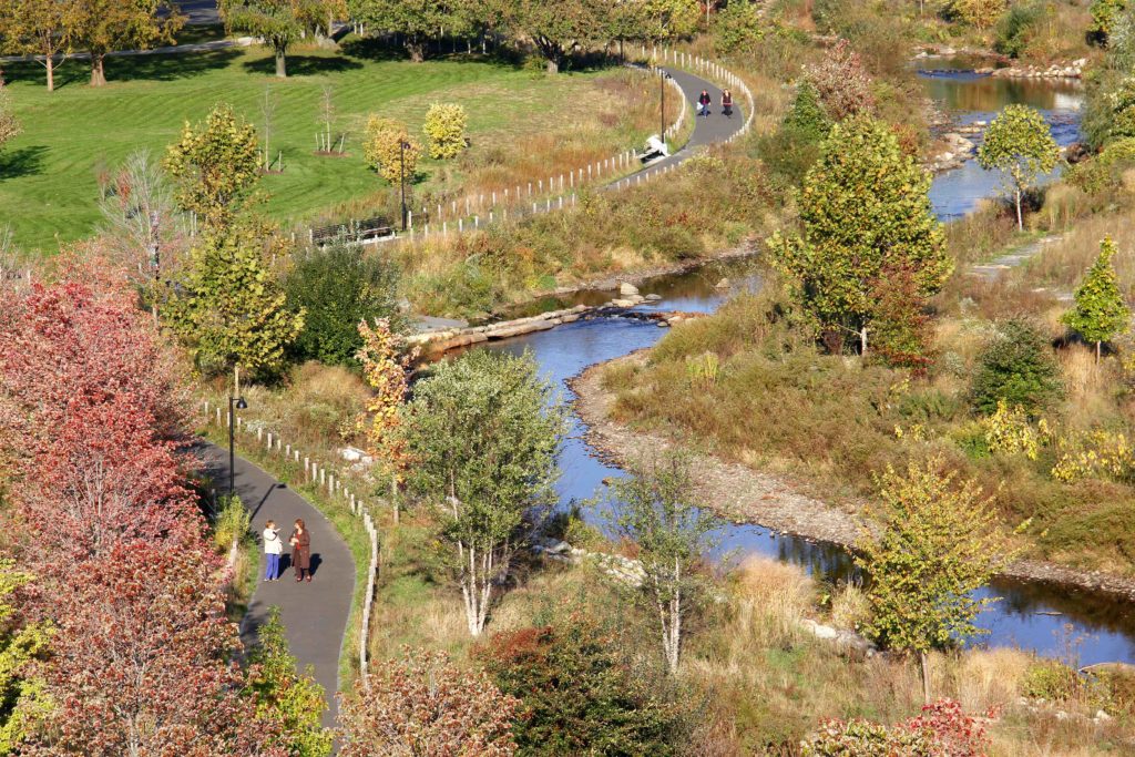
Community Reclamation of the River
Mill Riverpark and Greenway in Stamford, Connecticut is long greenway design, the 11.33 hectares (28 acres) park is spread over 4.8 kilometres (3 miles). It was initiated in 2007 by OLIN for the Mill River Collaborative that is located along the Rippowam River at the downtown Stamford, Connecticut, USA.
This river landscape project finished in 2013, was conceived to revitalise aquatic and terrestrial habitats, reduce flooding, restore the canalised river’s edge and to promote native planting. The project involved extensive community participation and was funded by a community collaborative of city, state, and the federal government, along with local corporations and private citizens.
The riverbank within the project area has dramatically evolved over the years from its intense industrial past of mill and manufacturing activities. In the 20th century it fell into despair, becoming an abandoned and unused green space; the river with the imposing concrete walls turned into an eyesore and a barrier between communities. The derelict and polluted river front had accumulated decades of debris and an unmanaged riparian edge choked the river leading to flooding.
In 2005 a master plan was developed to remove the concrete dam and restore the meandering river and to offer the community a maintainable and implementable public space for recreation, with a rich natural habitat of native flora and fauna. Besides the regulatory ecosystem services such as flood management, the renewed riverbank offered places for active and passive recreation and active interaction with river’s edge.
The large flexible green space is suitable for events which makes the place popular for waterfront entertainment. There is also the opportunity for contemplation and relaxation and using native planting in the landscape design promotes regionalism.
The project revitalised the aquatic and terrestrial habitat and reduced flooding by introducing native plants and restoring the natural meandering form of the river. By implementing green infrastructure principles, the project provided habitat rehabilitation and community public green space. It also accomplished an ecological revitalisation by bringing together a natural, protective flood plain, preventing flooding and managing the peak flow of water during a heavy storm event. The project was envisioned and developed in phases
Perception and Meaning
Accessibility
Legibility
Knowledgeability
Health and Wellbeing
Increased physical activities
Place affordance
Restorativeness
Interaction with Water
Visual
Tactile – touching
Website of the project:
https://www.theolinstudio.com/mill-river-park-and-greenway
Google map reference
The project shows that it is rated very well for aspects of accessibility, design, and facilities. The site visibility aspect is scored low along with protection of cultural heritage as there are no elements to take into account. In terms of health and well-being the site is perceived as highly restorative except for the aspect of the sense of being away.
As the site is highly accessible and frequented by visitors, the site is perceived to be safe and secure. The project is poorly scored for water connectedness and water safety, however. Except for water sports the project supports physical activities for formal, informal sports and children play.